
Embark on the Tsum valley trek, a journey into one of Nepal’s most secluded Himalayan valleys where Tibetan‑influenced monasteries, prayer flags and ancient traditions meet spectacular mountain views. Combined with the Manaslu Round route, this trek offers deep cultural immersion, pristine nature and a true off‑the‑beaten‑path adventure.
Tsum valley trek, also known as the Hidden Valley – a land of monasteries and hamlets with totally Tibetan population – lies on the northern part of Manaslu on the Nepal-Tibet border and used to be a restricted area until 2008. Although the region lies within Nepal, the Buddhism influenced region is a world of its own. Traditionally, Tsum used to be a separate area different from both Nepal and Tibet. The Tsum Valley region is still less exposed in comparison to other tourist areas, with relatively virgin and less beaten paths in comparison to the more popular regions. The Tsum people have their own way of family life, which may be quite surprising for many outsiders. All the brothers in the family are married to a single girl, what you may call a practice of polyandry. Compared with other areas, The Tsum Valley and Manaslu area is full of imminent mountains, passes, deep gorges, hamlets, gompas, chortens, and mani walls.
Tsum Valley Trekking is a sacred Himalayan pilgrimage valley situated in northern Gorkha,Nepal.’Tsum’ comes from the Tibetan word ‘Tsombo’,which means vivid.Traditionally,Tsum valley was a currently distinct geographical area called ‘Tsum Tso Chucksums’,which means thirteen provinces ruled as a single territory.Against the majestic backdrop of the Ganesh Himal,Sringi Himal,Boudha Himal ranges,this serene Himalayan valley is rich in ancient art,culture and religion.The local people are mostly of Tibetan origin & speak their own dialect.The altitude of Tsum Valley Trekking varies from 1905m in Lhokpa to over 5093m at Ngula Dhojhyang pass on the Tibatan border. The hidden valley is surrounded by the Boudha Himal and Himal chuli to the west,Ganesh Himal to the south & Sringi Himal to North.
Hightlights of the Tsum valley trek
- Spectacular sights of Ganesh and Manaslu mountains.
- Exploration of antique form of dialect, fine art, sophistication and religion
- Visit antique Rachhen Gumba and supplementary monasteries
- Observe innate existence and culture
- Explore Tibetan sophistication and tradition
- Wilderness hike to the hidden valley
- Refreshing bath in usual hot spring
Guideline for Tsum valley trek Itinerary
Day 01: Arrive Kathmandu & Transfer to Hotel – 1,300m/4,264 ft
Day 02:Kathmandu: Sightseeing and Trek Preparation
Day 03:Drive to Barpak (2000m/6560ft)
Day 04:Barpark to Laprak (2200m/7216ft): 6-7 hrs
Day 05:Laprak to Khorlabeshi (875m/2870ft): 7-8 hrs
Day 06: Khorlabeshi to Jagat (1410m/ 4625 ft): 6 hrs
Day 07: Jagat to Philim (1,590m/ 5215 ft): 3hrs
Day 8: Philim to Chumling (2363m/7775 ft):6/7 hours
Day 9: Chumling to Chokhangparo (3010m/9903ft): 5/6 hours
Day 10: Chokhangparo to Nile (3361m/11058ft), via Milarepa cave: 6/7 hours
Day 11: Nile to Bhajyo (Chhekya) (4030m/13218ft): 4 hours
Day 12: Acclimatize Rest at Bhajyo (Cheekya)
Day 13: Bhajyo to Rachen Gompa: (3240m/10627ft): 6 hrs
Day 14: Rachen Gompa to Chumje (3230m/10,595ft): 5/6hrs
Day 15: Chumje for Bihi (3130m/10,266ft): 4/5hrs
Day 16: Bihi to Namrung (2540m/8331ft): 6 hrs
Day 17: Trek from Namrung to Lho (3180m/10,430 ft): 4 hrs
Day 18: Trek from Lho to Samagaon (3530m/11,578 ft): 5/6 hrs
Day 19: Trek from Sama to Samdo (3860m/12,660 ft): 4/5 hrs
Day 20: Samdo – High Camp (Ekle Bhatti) (4460m/14,628fy): 5hrs
Day 21: High Camp – Bimthang (3,590m/11811ft), 7/ 8 hours walking
Day 22: Acclimatize day Rest day at Bimthang
Day 23: Trek Bimthang to Dharapani(1860m/6,100ft): 6-7 hrs
Day 24: Dharapani – Drive back by Jeep to Kathmandu
Day 25: free and shopping at Kathmandu
Day 26: Final Departure toward your homeland.
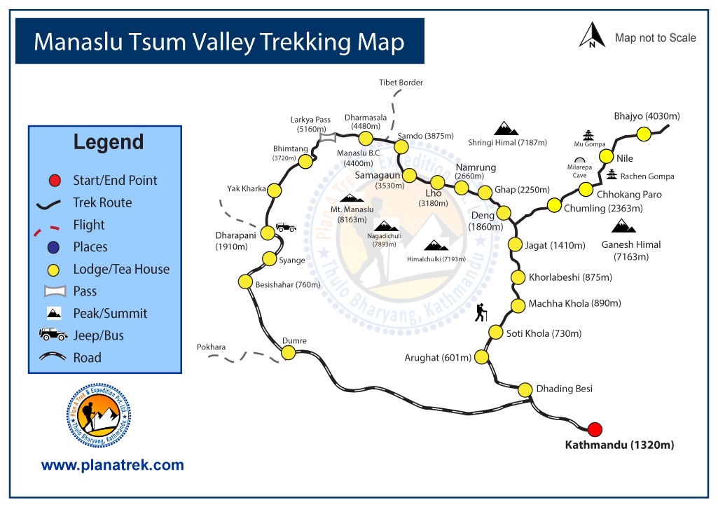
Tsum valley trek route map
Tsum valley trek Cost Include:-
- Airport pickup and drop
- 3 night hotel in Kathmandu with B/B basic
- Drive to Barpak by private jeep
- Local bus to Kathmandu from trekking ending point
- Manaslu conservation fee
- Manaslu trekking permit
- Tsum Valley Trekking permit
- Annapurna conservation fee
- TIMS card fee
- One English speaking guide
- One porter for two client
- 3 time food with menu basic during trekking
- Accommodation at local hotel with twin sharing
- Tea coffee three time in a day
- Nepali stuff insurance
- Guide, porter salary
- Guide, porter food and accommodation and transportation
Cost Exclude for Tsum valley trek:-
- Your international flight ticket
- Your travel insurance, Tips for trekking crew
- Hot shower, phone, internet, cold drink
- Any kind of alcoholic drink and bar bill
- Emergency evocation.
When is the best time to trek to Tsum Valley ?
- Sept-October – November and Autumn are Nepal´s peak and best time to go trekking.
- March – May is the second-best season of year to go trekking.
- December – January -February: the skies are clear but it can get very cold and there is a risk of passes being closed due to snow fall.
Detailed Tsum valley trek Itinerary
Day 01: Arrive Kathmandu & Transfer to Hotel – 1,300m/4,264 ft
Upon your arrival in the Kathmandu airport (TIA) you will be greeted by a representative from Plan a Trek, after completing your custom formalities.
Day 02: Kathmandu: Sightseeing and Trek Preparation
Today after breakfast we start a guided tour to several of the most historical and spiritual attractions in Kathmandu. Some of these landmarks are considered as World Heritage Sites; including the historic Durbar Square, the sacred Hindu temple of Pashupatinath, the famous ‘Monkey Temple’ (Swayambhunath) and Buddhist shrine (Bouddhanath) which is one of the large Stupas in the world. In the afternoon, there will be a pre-trip discussion where we can meet our trek leader and other team members Home of trek briefs us regarding our trek as well as provides us opportunity to ask any questions we may have regarding our upcoming adventure.
Day 03: Drive to Barpak (2000m/6560ft)
6 hours’ drive from Kathmandu into the western mountains takes us to Gorkha, the Capital of Medieval Nepal. We drive Kathmandu to Baluwa, and then take a local jeep to Barpak village which is situated upon the hilltop. Barpak is also home to Gaje Ghale, the 2nd World War veteran who also received Victoria Cross from the Queen of Britain.
Day 04: Barpark to Laprak (2200m/7216ft): 6-7 hrs
We trek through the mountains in an easterly direction into the main valley of the Budhi Gandaki River. A few hours of climb takes us to the pass of Gupsi Dada (3000m). The Gupsi Dada pass Laprak from Barpak, Enjoy the panoramic views of Buddhi, Shringi, Ganesh Himal and the Langtang range. From there, we descend down to Laprak, a beautiful Gurung village.
Day 05: Laprak to Khorlabeshi (875m/2870ft): 7-8 hrs
Trek further east to Manaslu main valley of the Budhi Gandaki river. We descend from Laprak and cross a suspension bridge. Then a steep climb around hillside. Pass the village of Singla while enjoying the magnifiscent views of the Manaslu Himal, and other Himalayas. Descend down to Kholrabeshi.
Day 06: Khorlabeshi to Jagat (1410m/ 4625 ft): 6 hrs
After a few more ups & downs, we reach to Tatopani. From the Hot spring we climb over another ridge, then cross the Budhi Gandaki on a suspension bridge. Climb on over a ridge to Dobhan. Crossing a suspension bridge over the Dobhan Khola, the trail climbs on a rugged trail to Duman. Crossing a suspension bridge over the Yaru Khola we climb the stone stairs and then drop to the river and again climb more stone stairs to Tharo Bharyang. Trek along the Budhi Gandaki river then climb towards the village of Jagat.
Day 07: Jagat to Philim (1,590m/ 5215 ft): 3hrs
Climb over a rocky ridge to Salleri, and then descend to Setibas. The valley widens a bit as the trail continues up to Ghatta Khola. Continue upstream to a long suspension bridge. Climb up to Philim, a large Gurung village.
Day 8: Philim to Chumling (2363m/7775 ft):6/7 hours
Walk past Philim to the north across a forest with the views of the narrowing valley. After Ekle Bhatti cross the gorge, and enter the pine tree forests. Descend down to trail going to the Tsum Valley. Climb through pine and rhododendron forests. Enjoy the views of Himalchuli mountains. Pass Lokpa, climbing further north through pines and rhododendrons. Climb down to Ghumlong, and climbing up to Ripchet. Crossing the Shiar Khola, finally arrive at Chumling. Visit the old Chumling gompa, and the stone streets of the village
Day 9: Chumling to Chokhangparo (3010m/9903ft): 5/6 hours
Cross the suspension bridge onto the opposite bank. Enjoy the great views of Ganesh Himal. Walk past Rainjham to Serpu Khola. Now we enter the hidden valley of Tsum. Another steep climb takes us to the village of Chhokangparo. Weather permitting, enjoy the views of Himalchuli at 7893 meters.
Day 10: Chokhangparo to Nile (3361m/11058ft), via Milarepa cave: 6/7 hours
While climbing above Chokhangparo, better to be careful of altitude problems. Walk past Lamagaon to the Rachen Gompa. Climb up to the Milarepa’s Cave. Then we cross the Shiar Khola. Continue walking through the villages of Phurbe and Pangdun. After crossing the village of Chhule, climb upstream and cross the bridge to finally arrive at Nile.
Day 11: Nile to Bhajyo (Chhekya) (4030m/13218ft): 4 hours
We are now almost close to the Tibetan border. Walk to the west bank of the valley through the Tibetan landscapes. Climb up to the Mu Gompa. From Mu Gompa, climb further up to Bhajyo and We are quite close to Tibet and get a good view of the Tibetan peaks as well as the Ganesh Himal range. Bhajyo is a remote area there is not any local houses. Only we can see some yak farm house. After having the lunch we will explore the area.
Day 12: Rest at Bhajyo (Cheekya)
We take rest at Bhajyo both for acclimatization and sightseeing. Discover the highland around Bhajyo. If the weather is clear, you can also enjoy the magnificent views of Ngula Dhojyang pass as well the glaciers of the Yamdro Valley.
Day 13: Bhajyo to Rachen Gompa: (3240m/10627ft): 6 hrs
From Bhajyo, we descend down to Rachen Gumba. Established in 1905 AD, the Rachen Gumba is a nunnery in the Shiar Khola Valley. The nunnery is one of largest in the region is of great importance. The interior of the Gumba is splendidly painted with Buddhist mural paintings.
Day 14: Rachen Gompa to Chumje (3230m/10,595ft): 5/6hrs
Continue south until a bridge crosses to the west bank then descend again to Chhokangparo. Drop below Chhokangparo on the previous trail for about 2hrs, until a small gompa is reached at Gho (2485m). Then taking the northern route in the lower Tsum Valley, we finally arrive at Chumje via Yaju.
Day 15: Chumje for Bihi (3130m/10,266ft): 4/5hrs
From Chumje, we continue on the northern route in the lower Tsum Valley. Pass the village of Dorjon Kharka just before reaching Rana. Crosss the large suspension bridge in the main valley of the Manaslu Budhi Gandaki River. If interested, walk further up to the village of Bihi.
Day 16: Bihi to Namrung (2540m/8331ft): 6 hrs
The initial part of today’s trek is on a relatively flat terrain. Soon, the trail moves uphill through the forest path. Thus we arrive at Namrung while enjoying at the same time the magnifiscent views of Manaslu, among others.
Day 17: Trek from Namrung to Lho (3180m/10,430 ft): 4 hrs
From Namrung, we again enter the Buddhism influenced region. Climb through the forest to Lihi. Enjoy the spectacular rise of the Ganesh Himal. Descend to Sho. Another steep climb takes us to our today’s campsite on a ridge.
Day 18: Trek from Lho to Samagaon (3530m/11,578 ft): 5/6 hrs
The Budi Gandaki is far down but we follow a small tributary instead. Walking in the shady fir forest is very enjoyable. A short climb to a plateau and the village Shyala. Huge mountains surround us, Himal Chuli and Peak 29 (Ngadi Chuli) to the left, Manaslu and large glaciers straight ahead, other snow summits to the right, at the far end of the valley we have just come from stands Ganesh Himal. At the far end of the village, overlooking the valley stands the well-known monastery of Sama. Sama Gaon is a village inhabited mainly by the Tibetans and lies at the foot of Manaslu.
Day 19: Trek from Sama to Samdo (3860m/12,660 ft): 4/5 hrs
Descend to the Budi Gandaki, that has turned north, and follow it to a bridge over a side stream. The trail to the left leads to the Manaslu Base camp. The Larkya la Trail passes several mani walls as the valley begins to widen. It is an easy trail on a shelf above the river passing the juniper and birch forests of Kermo Kharka. We drop off the shelf, cross the Budhi Gandaki on a wooden bridge and climb steeply onto a promontory between two forks of the river. From a stone arch we can see a large white kani, finally passing through the kani we find Samdo.
Day 20: Samdo – High Camp (Dharmasala) (4460m/14,628fy): 5hrs
We continue our walk down the edge, cross the wooden bridge over Budi Gandaki and begin walking upward. Cross two streams and witness the Larkya Glacier. Go around the valley of the Salka Khola and climb up again and come to the stone guest house (4450 m) which is not a lodge but a kind of shelter called Dharmshala, also known as Larkya Phedi. We camp here today and have a rest to prepare for tomorrow’s crossing of the famous and most awaited Larkya Pass. After a short climb, we reach the ablation valley on the North side of the Larkya Glaciers.
Day 21: High Camp – Bimthang (3,590m/11811ft), 7/ 8 hours walking
After an early start, we soon walk across the moraines of the glacier, making a gradual ascent which becomes steeper only in the last section to the pass. From the pass, there are outstanding views of Himlung Himal, Cheo Himal, Kangguru and the huge Annapurna II. Savor the spectacular views from the top of the pass. It is a longer day then usual to Bimtang, but to walk into these low pastures with the evening mist coming in and Manaslu; it’s an experience not to be missed.
Day 22: Rest day at Bimthang
We have been trekking incessantly for more than 2 weeks. Still one more week to trek in the mountains. Therefore, a rest day would prove a blessing for the tired muscles. Also discover the area surrounding Bimthang as well the cultural life of the mountain people.
Day 23: Trek Bimthang to Dharapani(1860m/6,100ft): 6-7 hrs
We will descend a great height today. Initially, from the valley of Burdin Khola, through rhododendron forests, to Karche, the highest cultivating place in the valley. Then we descend to the village of Gho. While staying on the north bank of the river, we trek into Tilje. Leave the Tilje Village, and cross the Dudh Khola. Cross a wooden bridge back to the northern side of the Dudh Khola. Continue to Dharapani.
Day 24: Dharapani – Drive back by Jeep to Kathmandu
Day 25: free and shopping at Kathmandu
Day 26: Final Departure toward your homeland
Frequently Asked Questions
1. How long does the Tsum Valley Trek take?
The standard Tsum Valley Trek takes around 14 to 18 days, depending on your pace and whether you combine it with the Manaslu Circuit or other side trips.
2. What is the best season for the Tsum valley trek in Nepal?
The best time for the Tsum Valley Trek in Nepal is during spring (March–May) and autumn (September–November), when skies are clear and trails are dry.
3. Do I need a special permit for the Tsum valley trek?
Yes. The Tsum Valley region is a restricted area, so trekkers must obtain a Tsum Valley Trek Permit and trek with a licensed guide through a registered agency in Nepal.
4. What makes the Tsum valley trek special?
The trek offers untouched Himalayan scenery, Buddhist monasteries like Mu Gompa, authentic Tibetan culture, and fewer crowds compared to popular trekking routes in Nepal.
5. How difficult is the Tsum valley trek Trek?
The Tsum Valley Trek difficulty level is moderate. Good fitness and some trekking experience are recommended, as trails include steep climbs and high-altitude terrain.


